


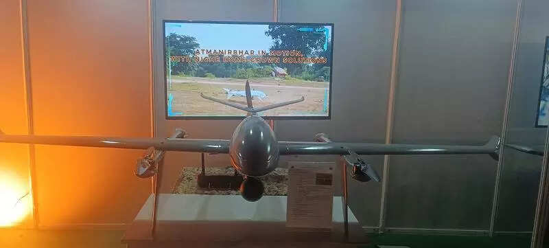
Senior officers noted that modern operations demand persistent aerial surveillance, rapid target acquisition, and real-time situational awareness—capabilities that proved decisive during Operation Sindoor.“It was designed with emphasis on endurance, range, and flexibility. The SOM drone has an operational range of 30km in a one-way mission profile and can operate at altitudes of up to 2,000 metres above ground level,” a senior Army officer told TOI.The drone was showcased during the Jointness Atmanirbharta and Innovation (JAI) seminar organised by Southern Command last week.“With an endurance of 120 minutes and speeds reaching up to 90 metres per second, the platform is tailored for sustained surveillance over contested or sensitive areas. Its ability to remain stable in wind speeds of up to 10 m/s enhances reliability in varied terrain and weather conditions,” the officer added.The drone features a fully indigenous carbon-fibre airframe and supports autonomous, tele-operated, and manual modes, enabling commanders to adapt its deployment based on mission complexity.“Features such as automatic take-off, position hold, and area survey directly address operational requirements identified by the field commanders during operations and exercises. Rapid deployment and minimal human exposure become critical factors in today’s technology-driven battlefields. These features were added to it,” said another officer.Its imaging system provides a significant operational advantage. Equipped with a daylight camera capable of recording 4K video at 30 frames per second and offering a combined zoom capability of up to 180x, the drone enables detailed stand-off observation.“Real-time video telemetry up to 30km without latency allows commanders to make time-sensitive decisions. This capability was increasingly seen as indispensable after Operation Sindoor highlighted the cost of delayed or fragmented intelligence,” the officers noted.Navigation is supported by a multi-constellation system incorporating IRNSS, GPS, Galileo, GLONASS, and BeiDou, with RTK capability ensuring high positional accuracy even in complex electromagnetic environments.The drone is designed to operate across multiple frequency bands and withstand temperatures ranging from –10°C to +50°C, aligning with India’s diverse operational theatres.Operational planners envision the system not only for surveillance but also for precision payload delivery and future integration with loitering munitions and electronic warfare suites. This adaptability mirrors the Army’s post-Sindoor emphasis on layered ISR, precision engagement, and unmanned dominance in the tactical battlespace.Trial runs validated its 30-km range at the Babina Field Firing Range in Aug last year. At an estimated cost of Rs 15.75 lakh per unit, the in-house development underscores the Army’s push for cost-effective indigenous solutions under the Atmanirbhar Bharat initiative.“As Operation Sindoor demonstrated, future conflicts will be decided as much by sensors and data dominance as by firepower. Systems like SOM signal the Army’s intent to internalise those lessons and institutionalise unmanned surveillance as a core operational capability. In that context, the development should be seen as a step in the right direction,” they added.